 Matlab
 Simulink
 NS3
NS3 OMNET++
 COOJA
COOJA CONTIKI OS
 NS2
NS2
Remote sensing is a technology that investigates the earth with help of satellites which is deployed with cameras and sensors. Generally, the manual observation of natural resources is quite difficult. In the event of this challenge developers and technology engineers have developed a mapping tool called GIS.
The acronym stands for the Geographic Information System. GIS will gather data like economic improvement of the nation, population information, and the plant types in the farmlands. The effective regulation of the tool is based on the assimilation of the general server information and their arithmetical investigations corresponding with the remote sensing road maps.
This article will enumerate the general thesis on GIS and Remote Sensing in detail!!
Now we will see about remote sensing and their thesis on GIS. Every technology supports some tools to enhance the process effectively. For the ease of your understanding, the developers of our concern made the key points very short and sweet. Let us have an understanding of the thesis on GIS and remote sensing.
Overview of GIS and Remote Sensing
- The data gathered by the remote sensing tool will be used in the Geographical Information System (GIS) assimilation
- The gathered data are always represented in the form of images
- The GIS Geographical Information System, itself indicates that it is a location-oriented information gathering tool
- It is the advanced graphic visualization technology that eliminates the traditional spreadsheet in capabilities
- Furthermore it the visualization of the issues will lead to safety measures in an earlier stage
This is all about remote sensing and Geographical Information systems in general. Usually, every researcher needs an expert’s guidance for effective outcomes. Now we will see about the road maps of remote sensing.
Steps involved in the Remote Sensing
- The sunlight rays directly explore the environmental atmosphere
- The earth surface reflected by the rays
- The reflected rays will be gathered by the cameras
- The captured rays will be turned into images
- The sensor will gather the images
- The gathered images will be stored in the database
- Then it will be displayed for the analytical purpose
These are the main steps involved in remote sensing as they are presented in hierarchical this will be very easy to understand. As of now, we had seen the Geographical Information System, remote sensing, and its road map in detail to formulate Thesis on GIS and Remote Sensing. It is time to discuss the source of remote sensing in brief.
What is the Data Source for the Remote Sensing?
- Data of the streets
- Data of the buildings
- Data regarding vegetation
- Integration of the data
The above-mentioned key points are the sources of remote sensing. We hope that it will be very easy to remember. Furthermore, we will see about the application of the Geographical Information System in remote sensing.
- The gathered information of the living and non-living creatures on the earth surface is subject to the zero interaction
- Sensors in the remote sensing are assimilated with the Geographical Information System for visualization and analytical purpose which will be very understandable
How does Remote Sensing works?
- Source (Sun)
- It is the primary source of the energy that is produced by the environment
- Direct solar radiance of the energy by the direct transmission of the primary source
- The intensity of the radiance is related to the improvement in the viewpoint of the related scene renewable energy
- Surface
- This is where the creatures of the earth is living, this surface is subject to the reflection of the radiance and the light produced
- Determination of the temperature and the radiation produced in the surface
- The terrain is the 3D landscape tool used to handle the queries and the generation of the mirrored reflection
- Atmosphere
- Visibility of the atmosphere
- The type of the atmosphere will be stated by the model on each particle presented in each layer
- The commotion of the images generated a lack of quality (Blurriness)
- The high volume of the particles leads to the haze in the absorption
- Transmission of the radiance which is produced in the atmosphere is subject to the remote sensing
- Upwelling and Downwelling Radiance
This is the way how the surface, atmosphere, and the ultimate source of remote sensing are integrated. The above-explained aspects will be effective for understanding. As our researchers made this article for ease of understanding which will lead the readers to explore the things in it.
We would like to share our victories with you, the company that served around 120+ countries in the world with our project and research ideas for Thesis on GIS and Remote Sensing. Additionally, we are having 5000+ happy customers who are served by our ideas. Without wasting time we will move to the next phase about the features of remote sensing.
Important Characteristics of Remote Sensing
- Spatial Resolution
- This is all about the least particles in the scenery which will be filtered out
- Spectral Resolution
- This is all about the sensors bandwidth and the specimen rate
- Temporal Resolution
- The satellites used in the sensors will repeatedly visit the Geolocation for several days based on their range
- The limitations of the SNR (Signal to Noise Ratio) and capacity lies on the high spatial or the low spectral ratio
- Radiometric Resolution
- This has capable of tracking the isolated and vibrant range signals and systems
- The satellites used here is Landsat 7 which has the capacity of 8-bit images, 256 unique grey values produced by the energy, and 2048 radiometric grey values which leads to immediate monitoring
We are doing researches in the various fields that are emerging now a day. They are mentioned below for your understanding. It is a worthy note to be taken as of now. Without wasting time we will have a quick summary of our research areas Thesis on GIS and Remote Sensing.
The researchers in our concern are habitually exploring them and transferring the technical facts in the research guidance!!
So far, we gave you a basic overview of remote sensing and the GIS in brief now is the time to understand the applications of the GIS in remote sensing. They come under the environmental, economic, and social development of sustainable cities.
What are the important aspects of GIS in Remote Sensing?
- Social Development
- Detecting the slum areas
- Population data and the computation of the quality of the life
- Assessment of challenges involved in the environment
- Economic Development
- Observation of the rural and urban areas
- Assessing the remaining usable land
- Evaluating the lands and their allocation
- Discovering the impaired building infrastructures
- Evaluation of the GDP (Gross Domestic Product)
- Environment Development
- Computation of the energy landscapes
- Renewable energy assessment
- Observing the land-use changes
- Evaluating the accurate population
- Evaluating the expansion of an urban area
- Evaluation of the pollution matrix
- Assessment of temperature conditions
Now we will see about the procedures or methods oriented with the Geographical Information System and Remote Sensing. The following techniques will let you know the key factors very keenly.
Methods for GIS and Remote Sensing
- Methods based on the Artificial Immune System
- DNA computing
- Cellular Automated Membrane computing
- Evolutionary computing
- Neuro-computing
- Methods based on the Swarm Intelligence
- Charge system search
- Gravitational search
- Bee huddling algorithm
- An artificial flock of fishes
- Bacteria hunting
- Firefly optimization
- Intelligent water drops
- Cuckoo search
- Swarm particle optimization
- Biogeography optimization
- Dynamics of the river formation
- Ant colony optimization
- Methods based on Theory
- Wisdom technology
- Anticipatory computing
- Granular computing
- Rough set theory
- Fuzzy set theory
- Perception-based computing
These are the methods involved in the Geographical Information System and remote sensing. We hope that you will understand the aspects explained. Our developers and researchers have done this article with essential aspects which are very needy in technology. Next, we will see about the latest ideas oriented with Thesis on GIS and remote sensing in detail.
Ideologies are the eminent thing while researching a technology. We are there for you to assist in the research areas!!
As we are providing research and project-related assistance to our scholars and the college students get our expert’s assistance in research areas. We assist in the fields of thesis writing, conference paper writing, system development, paper publication, and so on by well-organized experts. Do you surf for research guidance or thesis writing and then this is the right place to do it. We are providing 24/7 supports with a clear understanding.
Current trends on GIS and Remote Sensing
- Planning of urban development
- Disaster Alleviation and organization
- Earth observation and plotting following the remote sensing systems
- Organization of the water resources
- Impervious earthquake model
- Planning on traffic aspects and transportation construction
- Reintegration of the structures
- Ecological improvement and creation
These are the emerging ideas that are currently in trend. Knowing about the databases used in GIS and remote sensing is very important. To this, we have been mentioned the databases in the following passage. By observing the earth aspects, enormous volumes of the multi-spectrum, multi-temporal, multi-resolution pictures are produced which results in performance enhancements.
Databases used in the GIS and Remote Sensing
- NEO4J
- This database represents the geospatial information with the help of NEO4J libraries
- These libraries collect the logs and
- stores them for analysis
- Layers of the NEO4J consisted of the geometrics and geo indices
- The data acquisition is pillared with the help of Open Street Map and Shapefiles
- This easy approach stores the geometric indices in their well-known text or format (WKT)
- MONGO Database
- This has a format called coordinate pairs which will be added in the planners, for instance, JSON planner will be denoted as GeoJSON
- This database represents the geospatial vectors which are built in the form of spatial queries
- The coordinate pairs indicate the different geographic data structures
Performance Metrics in GIS and Remote Sensing
- Pointing the Accuracy Rate
- This is all about how the platform plotting the relevant scenes in the
- Frame Rate
- Evaluating the collection of the picture in each second to run a video
- Smear
- The time taken for the capturing will result in the effective object
- Range to Target
- This is about the distance between the platform range and the earth surface
- Flight Path
- For the view of the geometric aspects
- Jitter
- Casual regulation of the camera
- Time of the Integration
- This is about the time taken for the capturing of scenarios by per pixel
Master / doctoral thesis is a research study that is done by the students following real observation and experiments. This is an empirical research study that focuses on the student’s execution of the research till the climax. Now we will see about the components involved in the master thesis writing.
What are the chapters of Thesis Writing?
- Introduction of the Thesis
- Literature remarks
- Methods and modes
- Outcome
- Discussion
These are the aspects involved in the master thesis writing in general. Our researchers made this as simplest for ease of your understanding. It is time to write the thesis. There are four steps involved in effective thesis writing.
What are the phases in Thesis writing?
- Identify the theme and do a literature
- Identify the research gaps in the subject
- Enrich the results and give them reasons
- Frame the main theme
So far we gave you the overall perspective on the Thesis on GIS and Remote Sensing in wide. For any queries and guidance feel free to approach us.
“Let’s put hands together with us for the enrichment of the research and project ideas and grow with us”
Subscribe Our Youtube Channel
You can Watch all Subjects Matlab & Simulink latest Innovative Project Results

Our services
We want to support Uncompromise Matlab service for all your Requirements Our Reseachers and Technical team keep update the technology for all subjects ,We assure We Meet out Your Needs.
Our Services
- Matlab Research Paper Help
- Matlab assignment help
- Matlab Project Help
- Matlab Homework Help
- Simulink assignment help
- Simulink Project Help
- Simulink Homework Help
- Matlab Research Paper Help
- NS3 Research Paper Help
- Omnet++ Research Paper Help
Our Benefits
- Customised Matlab Assignments
- Global Assignment Knowledge
- Best Assignment Writers
- Certified Matlab Trainers
- Experienced Matlab Developers
- Over 400k+ Satisfied Students
- Ontime support
- Best Price Guarantee
- Plagiarism Free Work
- Correct Citations
Expert Matlab services just 1-click

Delivery Materials
Unlimited support we offer you
For better understanding purpose we provide following Materials for all Kind of Research & Assignment & Homework service.
 Programs
 Designs
 Simulations
 Results
 Graphs
 Result snapshot
 Video Tutorial
 Instructions Profile
  Sofware Install Guide
 Execution Guidance
  Explanations
 Implement Plan
Matlab Projects
Matlab projects innovators has laid our steps in all dimension related to math works.Our concern support matlab projects for more than 10 years.Many Research scholars are benefited by our matlab projects service.We are trusted institution who supplies matlab projects for many universities and colleges.
Reasons to choose Matlab Projects .org???
Our Service are widely utilized by Research centers.More than 5000+ Projects & Thesis has been provided by us to Students & Research Scholars. All current mathworks software versions are being updated by us.
Our concern has provided the required solution for all the above mention technical problems required by clients with best Customer Support.
- Novel Idea
- Ontime Delivery
- Best Prices
- Unique Work
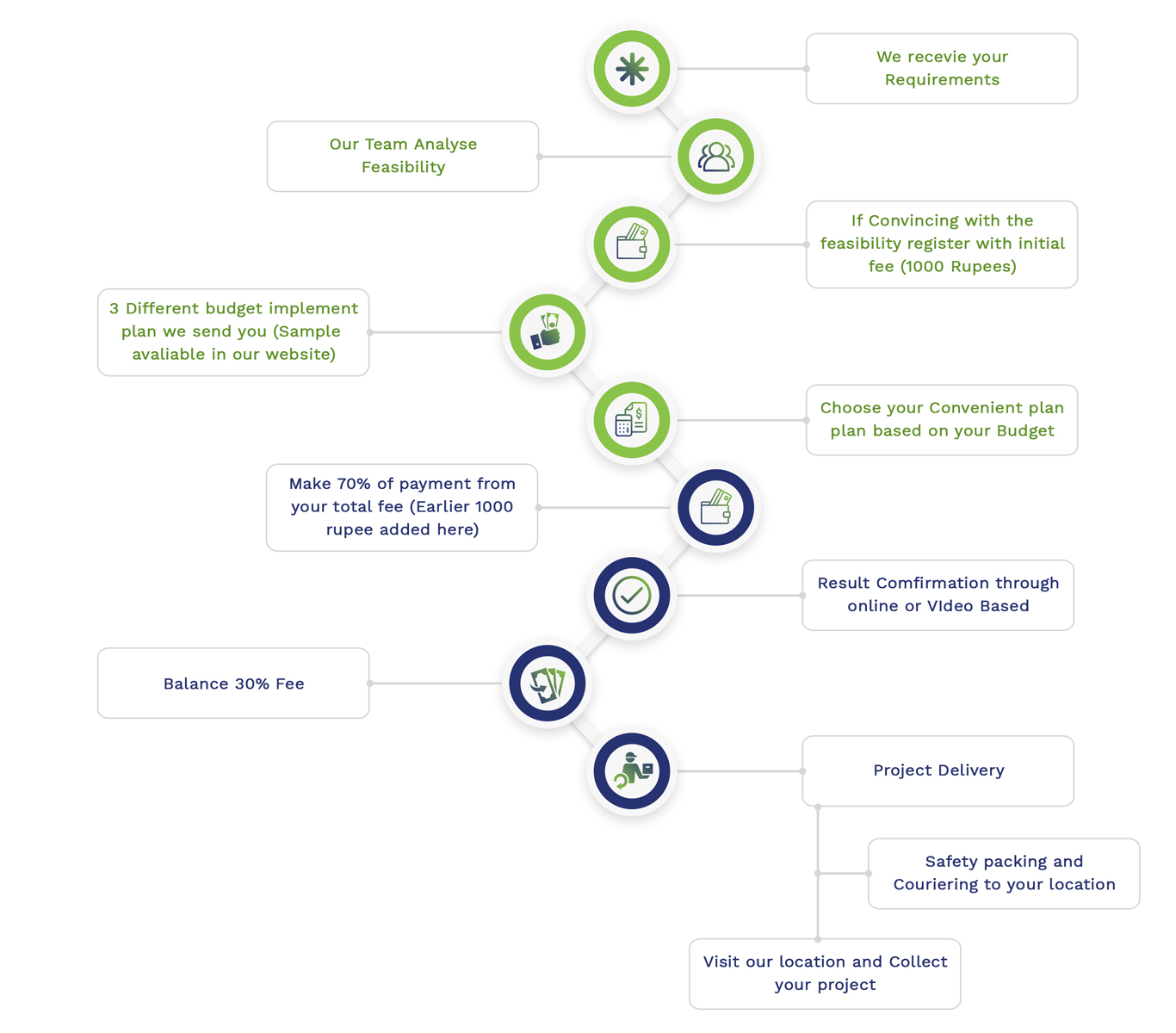
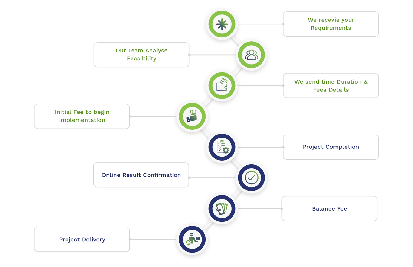
Simulation Projects Workflow
Embedded Projects Workflow