 Matlab
 Simulink
 NS3
NS3 OMNET++
 COOJA
COOJA CONTIKI OS
 NS2
NS2
REMOTE SENSING MATLAB
Remote Sensing is a process of getting information about multiple objects on the planet without any interaction of the human. Remote sensing images are captured with the help of satellites. Remote sensing matlab will help us to examine the status of the geologic and Geo-spatial environments. Remote sensing based matlab projects are focusing the principles and techniques for the purpose of data collection and interaction of electromagnetic energy with geologic earth surface. Process behind in remote sensing are acquiring, processing and interpreting images to obtain information about satellite images. Remote sensing matlab projects are developed for many engineering students and research scholars. Remote sensing imagery can be captured and produced different format of images like ASTER, SAR and SONAR.
Elements of Remote Sensing Matlab:
Several elements are presented in the electromagnetic remote sensing system. Elements are radiation and the atmosphere, recording of energy by the sensor, interpretation and analysis, energy source or illumination, interaction with the target, transmission, reception and processing and application.
Types of Remote Sensing Matlab Systems:

Remote sensing systems are categorized into active remote sensing and passive remote sensing. In passive remote sensing the source of energy which is naturally available named as sun. This source of solar energy called as EMR which is frequently used passive mode. Passive mode will ensure signal strength received at the destination of sensor, wavelength bands. These properties are easily traversing through the atmosphere without any loss. In active remote sensing energy can be generated and forward to the targets with the help of remote sensing platform. The reflected energy could be collected from the target to be recorded by sensor available in the remote sensing platform. Microwave remote sensing can be done due to the active remote sensing.
Applications of Remote Sensing Matlab:
- Agriculture.
- Urbanization and Transportation.
- Natural Resource Management.
- Land use.
- Mapping.
- Water Management.
- Aviation.
- Disaster management.
- Coastal management.
Remote Sensing Matlab based Projects:
Several projects are created and developed on to the domain of remote sensing. Normally, remote sensing applications are crated with the help of high resolution images. Object classification can be performed on to the ASTER images. In that process lineament features are separately classified using object classification method. Lineament features are segregated and also mentioned its area in percentage. SONAR images also used for some applications like underwater sea detection. Automatic detection of underwater sea position could be examined with the help of some of the object detection algorithms and methods. SAR images are frequently used remote sensing images used for detect the changes the earth surface, shadow detection and removal in geologic structures. Shadow detection and removal process can be done with the help of segmentation, elimination of suspected areas, boundary extraction and shadow removal. Changes in the earth surface can be detected using fusion methods and algorithms and also done the process of non-sub sampled decomposition. Ground truth image to be set for the identification of changes presented in the SAR images.

Advantages of Remote Sensing Matlab:
- Actuality.
- Ex-territoriality.
- Objectivity.
- Immensity.
- Affordability.
- Capability to stop action.
- Rapid data collection.
- Cost savings.
- Increased spatial resolution.
- Improved vantage point, synoptic view.
- 3D perspective.
- Quantitative analysis.
Recent Advancements in Remote Sensing:
Recent advancements in remote sensing and Geo-information processing will focus several features. Some of the features will support the process of comprehensive sensing, SAR image processing, pan-sharpening and sparse representation. In our concern we offer more number of remote sensing applications using matlab for researchers in the engineering and scientific fields.
Uses of Remotely Sensed Images:
- Delineate Patterns.
- Quantitative Measurement of Landscape Properties.
- Other information can be portrayed.
- Determine areas and extent of different cover types and conditions.
Subscribe Our Youtube Channel
You can Watch all Subjects Matlab & Simulink latest Innovative Project Results

Our services
We want to support Uncompromise Matlab service for all your Requirements Our Reseachers and Technical team keep update the technology for all subjects ,We assure We Meet out Your Needs.
Our Services
- Matlab Research Paper Help
- Matlab assignment help
- Matlab Project Help
- Matlab Homework Help
- Simulink assignment help
- Simulink Project Help
- Simulink Homework Help
- Matlab Research Paper Help
- NS3 Research Paper Help
- Omnet++ Research Paper Help
Our Benefits
- Customised Matlab Assignments
- Global Assignment Knowledge
- Best Assignment Writers
- Certified Matlab Trainers
- Experienced Matlab Developers
- Over 400k+ Satisfied Students
- Ontime support
- Best Price Guarantee
- Plagiarism Free Work
- Correct Citations
Expert Matlab services just 1-click

Delivery Materials
Unlimited support we offer you
For better understanding purpose we provide following Materials for all Kind of Research & Assignment & Homework service.
 Programs
 Designs
 Simulations
 Results
 Graphs
 Result snapshot
 Video Tutorial
 Instructions Profile
  Sofware Install Guide
 Execution Guidance
  Explanations
 Implement Plan
Matlab Projects
Matlab projects innovators has laid our steps in all dimension related to math works.Our concern support matlab projects for more than 10 years.Many Research scholars are benefited by our matlab projects service.We are trusted institution who supplies matlab projects for many universities and colleges.
Reasons to choose Matlab Projects .org???
Our Service are widely utilized by Research centers.More than 5000+ Projects & Thesis has been provided by us to Students & Research Scholars. All current mathworks software versions are being updated by us.
Our concern has provided the required solution for all the above mention technical problems required by clients with best Customer Support.
- Novel Idea
- Ontime Delivery
- Best Prices
- Unique Work
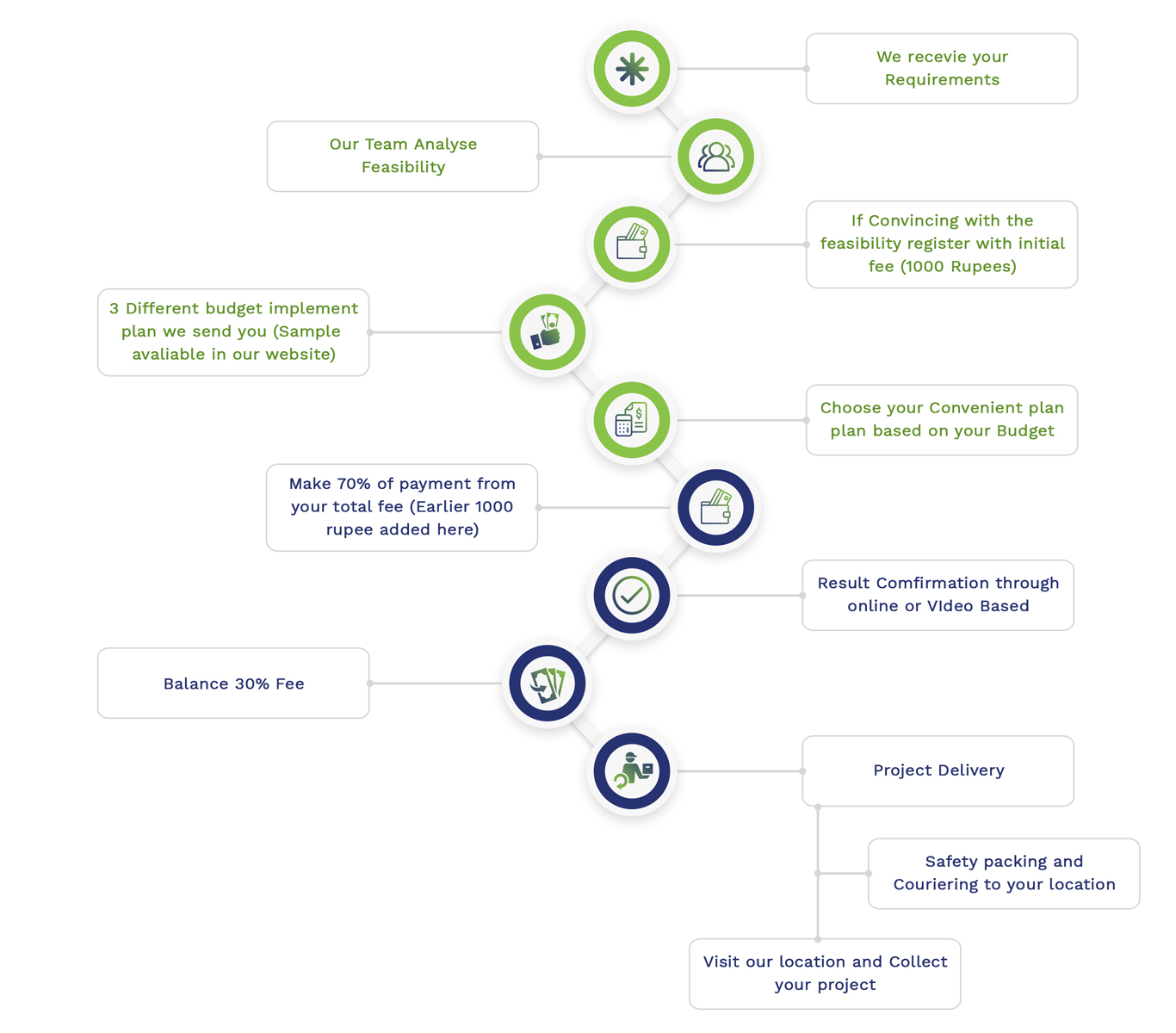
Simulation Projects Workflow
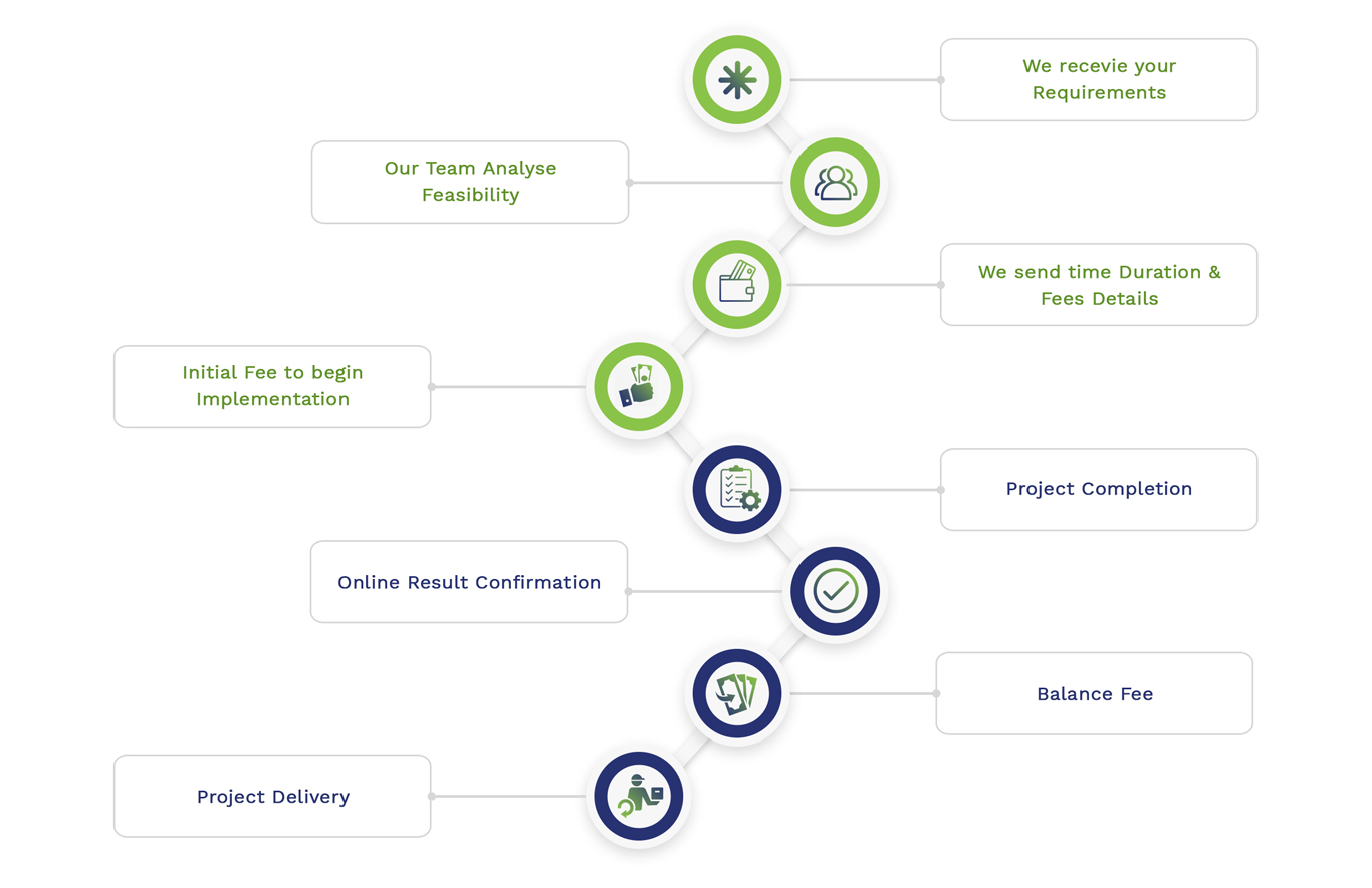
Embedded Projects Workflow